June 11, 2012

Copper Ridge Dinosaur Tracks and Petroglyphs, Moab, UT

This is a post I had written up back in November, but forgot to post and has been sitting in my archives. Better late than never...
The view north from Copper Ridge

Just north of Moab on your way to Green River, there is an unsigned dirt road that heads 2 miles out to the base of Copper Ridge. At the parking area, there is a short trail up the slope to the Jurassic Age dinosaur tracks. There is a platform of wavy mudstone, only about 30 feet long where the tracks are located. There are two specific tracks.


One set of tracks include a sauropod, thought to be either a Diplodocus or Apatosaurus. What is amazing about this particular set of tracks, is that it is the only set of tracks known where a dinosaur made a 90 degree turn.

Above, you can see where the in the image,
the sauropod was walking (what appears to be downhill) and then turns right.

Unfortunately, the image of the Allosaurus tracks at this site will not load properly into this blog. But, here it is sideways. 


But, at another site, down the Potash Road just outside of Moab, there is a set of Allosaurus tracks located at the trailhead for the Poison Spider Trail.


Also down the Potash Road are numerous petroglyphs on the cliffs right along the Colorado River. Many of them appeared to be "alien-like" creatures, as well as, the normal assortment of bighorn sheep, deer, and snakes.


But, one petroglyph that really stood out was a very clear image of a bear. It's unlikely bear were living down in the Colorado River Gorge at the time, but the nearby La Sal Mountains would most definitely have been a habitat for them. In addition, often the images on petroglyphs are thought to represent clans and spiritual beings rather than the animals themselves.


Below are some additional petroglyphs. Just be careful because there are so many that you don't want to be looking up and swerve into on-coming traffic. It's much better just to pull over a bunch of times.


June 10, 2012

East Clear Creek, Mogollon Rim, AZ


We leave Arizona on Tuesday for summer up in the beautiful Pacific Northwest, but before we do, I wanted to pass along some photos of our camping trip out at East Clear Creek near the edge of the Mogollon Rim at 7,400 feet.


Due to the porous nature of the rocks in this region, surface water is rare. East Clear Creek offers one of the few, non-muddy, opportunities to enjoy the lush riparian zone on top of the rim. This creek heads across the rim and then down to the north through Winslow before meeting up with the Little Colorado River, which eventually joins the Colorado River in the Grand Canyon.


The site is about 70 miles from Flagstaff in the Coconino National Forest. Upon arrival, we set up camp along the banks of the creek under the shade of majestic Ponderosa pines.


The substrate is Coconino Sandstone, which are the remains of an ancient desert that once covered this region with sand dunes hundreds of feet high. The cross-bedding is evident in the image below. Each change of angle represents a new sand dune that formed on top of the older ones that lithified when water drained through the sand and cemented the sand particles together.


Hilina absolutely loved playing in the creek, trying to catch crawdads and little fish fry, and otherwise having a grand time.


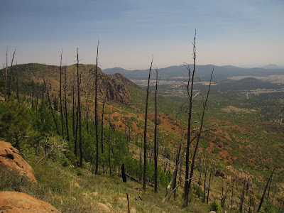
A few miles further south came the edge of the Mogollon Rim. The edge of the rim sits 2,000 feet above the Tonto Basin below. This escarpment runs over 200 miles from west of Williams all the way to New Mexico.   In the image above, you can see the effects of a fire that ran up this canyon.


From here, you can look across the Tonto Basin to the Mazatzal Mountains and out to the Sonoran Desert beyond. The town of Payson is visible in places. We used to live at the base of the Mogollon Rim in Young, AZ some years back and to get to town for groceries always had to ascent and then descend the rim (2,000 feet each way) to get to Payson. It was a 20 mile dirt road off of Highway 260 and then 30 more miles on pavement to Payson.


On the way back, we traveled past Mormon Lake. This odd geologic feature looks like a large volcanic caldera filled with a very shallow muddy lake. The lake expands and contracts through the year, but is rarely more than a few feet thick. I've researched it before and have never found any evidence that it is volcanic in origin (other than the lava rocks on the surface). The San Francisco Peaks and Flagstaff are visible in the distance about 30 miles to the north. I actually have some students of mine who live along the lakeshore in a small private enclave surrounded by national forest land.


June 3, 2012

Early June on Mount Elden, Flagstaff, AZ


Only one week until we begin out journey north to the Olympic Peninsula. But, with temperatures in the 80's, it was a great weekend to head up onto the 9,000 foot summit of Mount Elden, which is literally in our backyard. Both Linda and I had been to the summit by hiking the 2,000 foot slope previously (and individually), but we wanted Hilina to have a chance to go up there as well, so we drove up the radio tower access road to the ridgeline and then began hiking from there on the Sunset Trail.


The sky was clear, but a bit smoky from the big fires in New Mexico. But, being up on these slopes is a great lesson in fire ecology, as Mount Elden burned in a catastrophic human-caused fire in 1977. Since the fire occurred in the driest part of the year (May and June) before the summer monsoons arrived, once the fire was out and the heavy monsoon rains begun, it literally washed away all of the soil. Thus, regeneration has been painfully slow. In fact, scientists believe it will take more than 1,000 years for the ponderosa pine forest to return to its slopes.


In fact, the historically, fires in this region would not have begun until lightning strikes during the wet monsoon season started them. But, since conditions were wetter, the fires were smaller and mostly stayed on the ground, actually improving the forest ecosystems. But, most major fires of the southwest today are human caused and occur during the ultra-dry late spring (May and June) before the monsoons arrive to put them out.


But, on the north-facing slopes, which were cooler, wetter, and where the fires would have to go downslope after reaching the crest did not burn or only burned on the forest floor. As such, there trees are dense and there is a plethora of regrowth of young conifers and aspens.

The aspens are regenerating on the north-slope (left), while the south-slope is barren

Another interesting ecological concept easy to see up on this ridge are the climatic differences between north and south aspect. North-facing slopes are cooler and wetter because they remain in the shade all winter, while south-facing slopes get the direct sunlight. Thus, snow and rain linger longer on north-facing slopes, the soils do not dry out as quickly, and the trees are less exposed to the desiccating effects of the sun. In addition, since most of the prevailing winds come from the southwest, these south-facing slopes also experience more of the desiccating winds and hoar-frost in winter.

An example closer to what these forests should look like

The Four Forests Restoration Initiative is an attempt by the U.S. Forest Service to restore these forests back to their originally ecological state. That was large ponderosa pines, widely spaced apart, with frequent (every 5 years) low-intensity ground fires that burn off shrubs, fallen branches, and small trees that create ladders for fires to climb up into the canopy. The four national forests of Northern Arizona include the Coconino, Kaibab, Apache-Sitgreaves, and Tonto. The best way to restore these forests is through the use of thinning of small and dense trees and through frequent prescribed burns. It is critical no human-caused fires occur during the hot-dry period in May and June, but are allowed to burn (under strict monitoring) during the monsoon season of July-September.

A view down to our house, located about in the exact center of this image
From the top of Mount Elden, you can see the entire city of Flagstaff. It is quite obvious that the city is a long linear strip following the railroad tracks and I-40 only about 2 miles wide and about 10 miles long. 

Hilina and Linda relaxing on a huge old southwestern white pine snag

Hiking up here, literally one mile as the crow flies from our home, reminded us why we moved here to Northern Arizona. The recreational opportunities are boundless. There is so much diversity, from the Sonoran Desert to dense forests to alpine meadows all within 2 hours of Flagstaff.

The 12,630 foot San Francisco Peaks from Mount Elden.
They are the highest peaks in Arizona and the only true alpine area in the state.


Flagstaff and beyond